The Tibetan Plateau (TP), often referred to as the 'Asian Water Tower', plays a critical role in regulating the hydrological cycle and influencing global climate patterns. Its unique topography and climatic conditions result in pronounced seasonal freeze-thaw (FT) dynamics of the land surface, which are critical for understanding permafrost ecosystem responses to climate change. However, existing studies on FT dynamics over the TP are limited by either short observational periods or deficiency in accuracy, failing to capture the long-term FT processes comprehensively. This study presents a novel satellite-based approach for monitoring the FT dynamics over the TP from 1979 to 2022, utilizing passive microwave observations. We developed a new algorithm that integrates discriminant function algorithm (DFA) with a seasonal threshold algorithm (STA), employing the freeze-thaw index (FTI) as the classification variable to determine optimal FT thresholds. The strong performance of the algorithm was confirmed by in-situ validation, with an overall accuracy of 91.46%, a Kappa coefficient of 0.83, and an F1-score of 0.92, outperforming other remote sensing-derived FT products such as SMAP (OA = 89.44%, Kappa = 0.79, F1 = 0.89). Results reveal significant changes in surface freeze-thaw dynamics over the past four decades. Between 1988-2022, frozen days exhibited a significant decreasing trend of -0.19 daysyear(-)(1), primarily attributed to the delayed freeze onset (0.19 daysyear(-)(1)), while thaw onset showed no significant trend. Spatially, permafrost regions experienced a more pronounced decrease in frozen days and earlier thaw onset compared to seasonally frozen regions. Moreover, marked interannual trend differences in FT processes were observed across elevation gradients, with higher elevations showing more negative trends in frozen days and thaw onset. This study provides a reliable and up-to-date analysis of surface FT process changes over the TP, informed by long-term satellite-based observational perspectives. These analyses revealed marked spatial heterogeneity in surface FT dynamics across the TP region, underscoring the impacts of climate change on the cryosphere and hydrology.
The Tibetan Plateau (TP), known as the 'Asian Water Tower', poses significant challenges for hydrological modeling due to its complex cryospheric processes and parametric uncertainties. To address these challenges, we developed an integrated evaluation framework that combines spatiotemporal performance metrics with three global sensitivity analysis methods, based on the Variable Infiltration Capacity (VIC) model. Four alpine river basins were used as case studies to assess the impact of 33 parameters on nine hydro-energy variables across daily, seasonal, and spatial scales. Key drivers of spatial heterogeneity in parameter sensitivities were identified. The results indicate that snow albedo, leaf area index, and the soil drainage parameter broadly influence multiple processes. Runoff and baseflow sensitivities vary spatiotemporally. Random Forest-based SHapley Additive Explanations analysis reveals an east-west gradient in parameter sensitivity, driven by temperature, precipitation, and radiation. Two-step parameter optimization improves the average daily simulation efficiency and spatial consistency for land surface temperature and snow cover fraction by 33% and 30%, respectively, without compromising runoff accuracy. Transferring parameter sensitivities to similar basins confirms the framework's robustness and generalizability. This study underscores the importance of non-runoff parameters, enhances simulation performance, and provides insights into seasonal hydrological variability for more robust model applications across the TP.
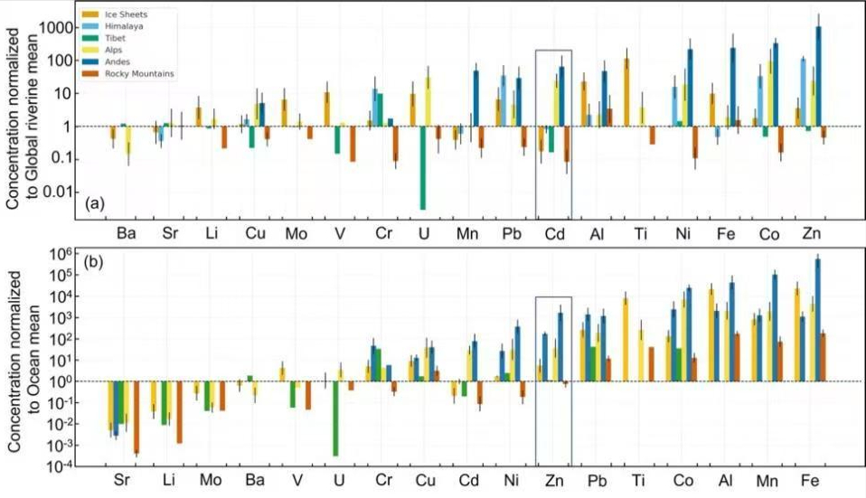
全球变暖背景下冰川加速退缩,冰川融水化学组成持续发生改变,山地冰川环境中的溶解态痕量金属既是下游生态系统所需的关键微量营养元素,也可能成为潜在污染物,其释放正受到越来越多关注。然而,目前不同类型冰川系统中痕量金属迁移释放的控制机制仍缺乏系统认识,特别是对山地冰川与极地冰盖的对比研究不足。 中国科学院西北生态环境资源研究院冰冻圈科学与冻土工程全国重点实验室康世昌研究员团队,开展了全球尺度山地冰川与极地冰盖融水中溶解态痕量金属浓度及迁移特征对比研究。该研究整合了喜马拉雅冰川新的野外观测数据,以及青藏高原、安第斯山、落基山、阿尔卑斯山、格陵兰冰盖和南极冰盖等区域的已发表数据,系统评估了冰川类型对痕量金属释放的控制作用。 研究发现,山地冰川溶解态痕量金属迁移释放能力显著强于极地冰盖,其融水中Zn、Co、Ni、Cd 和 Cu 等元素的浓度明显更高,较全球河流和海洋参考值高出 1 - 2 个数量级,证实山地冰川是更为活跃的溶解态痕量金属释放源。这种差异与山地冰川流域更强的水-岩相互作用、更复杂的岩性组成、更快速的排水系统以及更多新鲜磨蚀反应颗粒密切相关,而极地冰盖则更多受较长的冰下水体停留时间及不同地球化学环境的影响。 研究进一步表明,冰川退缩释放的化学成分对下游生态系统具有双重效应。冰川融水可向贫营养环境输送具有生物学意义的痕量元素,也可能增强潜在有害金属的迁移释放,从而影响下游淡水水质。因此,该研究将冰川地球化学的重要性由单纯的元素迁移问题,拓展到冰冻圈变化与人口密集流域水质安全、生物地球化学过程之间的关联研究,为全球冰川区环境风险评估提供了重要的科学依据。 该成果以Glacier-specific controls on enhanced trace metal mobility across global mountain and polar meltwaters为题,发表在国际期刊 Communications Earth & Environment上。西北研究院博士后Shipika Sundriyal为第一作者,Tanuj Shukla 副研究员为通讯作者。该研究得到甘肃省博士后科研基金的资助。 论文链接:https://doi.org/10.1038/s43247-025-03064-9. 冰川与冰盖融水中痕量金属浓度相对于全球河流和海洋平均浓度的对比 全球尺度下冰川与冰盖融水中痕量金属的迁移释放特征
2026-04-14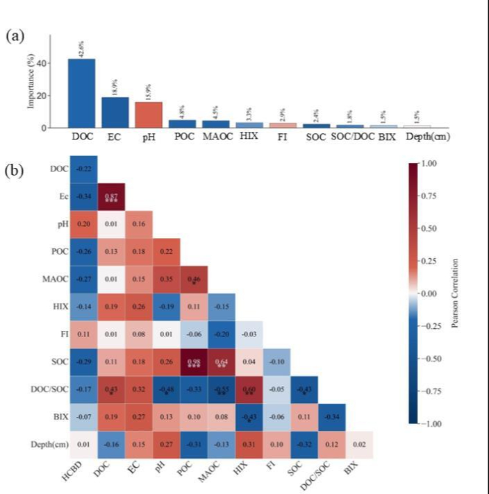
北极地区是气候变化的敏感区,同时受人类活动直接干预程度较低,受持久性有机污染物“全球蒸馏效应”影响,该区域成为此类污染物的重要富集区。当前气候变暖导致北极冻土持续退化,而六氯丁二烯(HCBD)作为新型持久性有机污染物,其在北极地区多年冻土中的空间分布特征、赋存总量及迁移机制尚缺乏系统性研究与深入探索。 中国科学院西北生态环境资源研究院冰冻圈科学与冻土工程全国重点实验室张玉兰研究员团队,在北极阿拉斯加地区开展了多年冻土样品采集与分析,系统揭示了该区域多年冻土中HCBD的赋存特征。研究获取了不同冻土剖面HCBD浓度数据,为深入认识高纬度冰冻圈环境中持久性有机污染物的迁移转化过程提供了重要基础数据。 研究结果显示,阿拉斯加北极多年冻土中HCBD浓度范围为0.0551至2.08 ng/g-dw,平均值为0.43 ± 0.40 ng/g-dw 。值得注意的是,该浓度水平与北极及青藏高原土壤中传统持久性有机污染物(如六氯苯和多氯联苯)的水平相当,甚至略高。基于一级质量平衡模型,研究团队初步估算出阿拉斯加多年冻土表层30cm内储存了约160吨的HCBD。这一数据有力证明,北极多年冻土不仅是全球重要的碳库,同时也是持久性有机污染物的关键储库。 为剖析影响污染物在冻土中保留与迁移的关键驱动因子,研究团队引入了随机森林模型进行归因分析。研究发现,溶解性有机碳是影响HCBD空间分布的主导因子(贡献率超过42%),凸显了由pH值和电导率调控的“溶解性有机质中介传输”在冻土环境中的核心作用。同时,利用菲克扩散定律分析揭示了HCBD在冻土活动层中的双向迁移模式:在浅层表现为受冻结浓缩和挥发驱动的向上迁移,在深层则表现为受溶解有机碳(DOC)介导的向下渗透与累积。 研究指出,多年冻土正经历从污染物“汇”向潜在“排放源”的转变。该研究成果不仅丰富了持久性有机污染物在冰冻圈的赋存特征认识,也为科学评估极地生态风险、制定全球化学品监管政策提供了重要科学支撑。 相关研究成果以Spatial distribution, retention and transport of hexachlorobutadiene in Arctic permafrost soils为题发表于环境科学领域期刊Environmental Pollution上。西北研究院博士研究生康强强为论文第一作者,张玉兰研究员为通讯作者。该研究得到国家重点研发计划和甘肃省重大科技专项共同资助。 论文链接:https://doi.org/10.1016/j.envpol.2026.128038 环境因子与HCBD浓度关系的随机森林模型结果及相关性分析。(a)随机森林模型中各环境变量的特征重要性,按其对HCBD浓度预测的贡献度排序。(b)HCBD与环境因子的Pearson相关矩阵;红色和蓝色方框分别表示正相关和负相关。 多年冻土剖面中HCBD迁移的垂直分布。图中颜色表示HCBD的迁移方向(蓝色向上,红色向下),圆圈大小反映迁移强度。
2026-04-10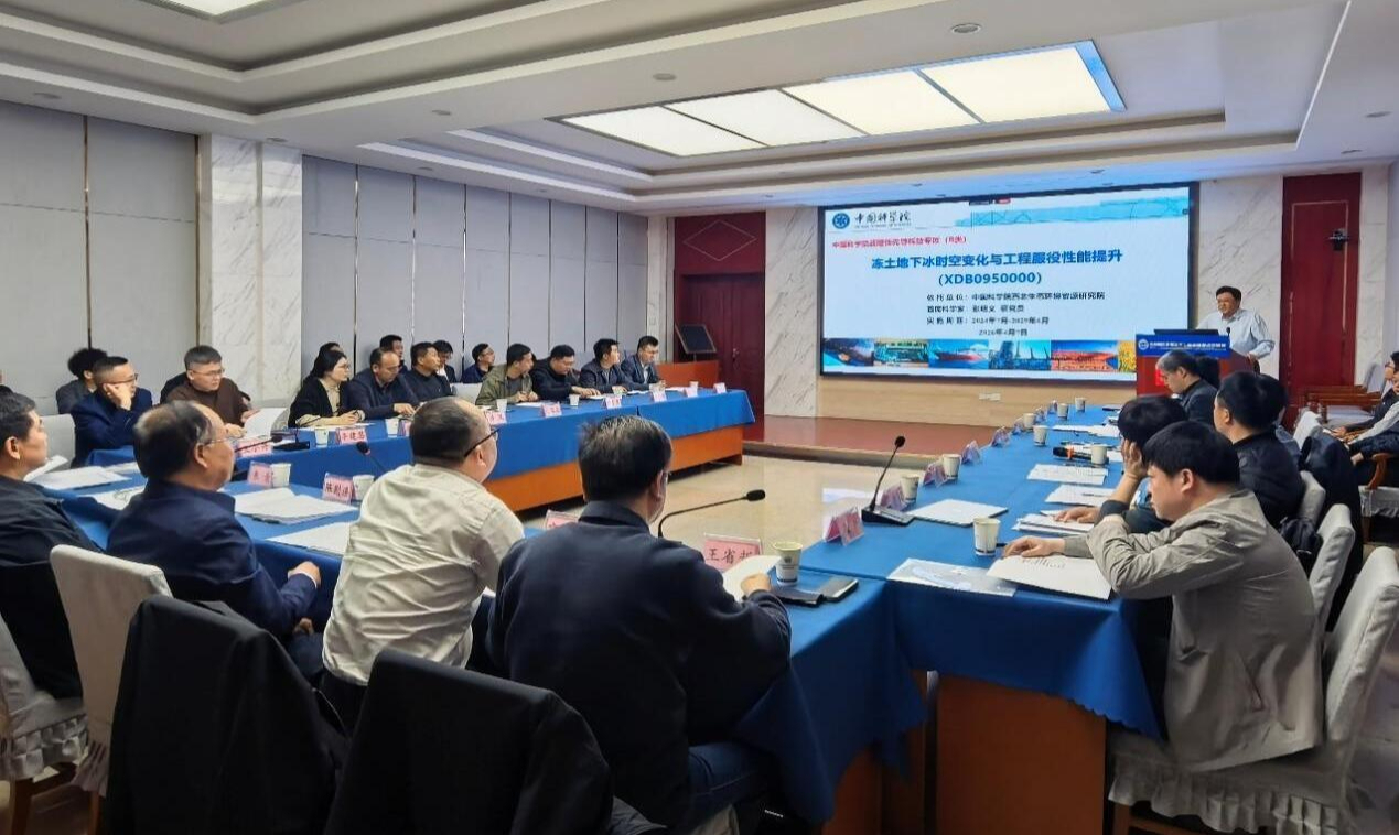
4月7日,中国科学院战略性先导科技专项(B类)“冻土地下冰时空变化与工程服役性能提升”2025年度会议在兰州顺利召开。 会议特邀中国科学院西北生态环境资源研究院院长冯起院士,中国科学院可持续发展科技研究局地球与资源处处长段晓男,项目年会专家组成员甘肃省气象局张强院士,中国铁路设计集团有限公司陈则连副总工程师,中国科学院南京地理与湖泊研究所朱青研究员,中国石油大学(华东)宗兆云教授,兰州理工大学殷占忠教授,兰州大学王省哲教授,中南大学张升教授,中国科学院、水利部成都山地灾害与环境研究所王小丹研究员,中国地质大学(武汉)李建慧教授,中国科学院青藏高原研究所曹斌研究员出席。专项、项目、课题负责人及科研骨干等60余人参会。会议由西北研究院重大任务处处长史宝光和张强分阶段主持。 冯起代表专项依托单位致辞。他表示,专项自实施以来整体推进顺利有序,已在导出国家重大科技任务上取得突破。后续要紧密围绕出疆入藏战略大通道建设等国家重大战略需求,聚焦冻土工程与生态环境核心问题,深耕科技攻关,力争产出一批用得上、有影响的科技创新成果,切实服务国家重大工程建设与区域生态安全。 段晓男代表中国科学院主管业务局发言,对专项下一阶段工作提出建议,强调需进一步强化制度建设、档案管理、财务规范等全流程管理,系统谋划产出标志性成果,持续提升组织实施能力和科研引领力,推动各项研究任务高质量落地见效。 专项工作汇报阶段由专家组组长张强主持。首席科学家张明义研究员全面汇报了专项立项背景、年度进展、亮点成果及组织管理情况等。游艳辉研究员、张玉兰研究员、裴万胜研究员分别汇报了各项目的年度进展情况。 专家组在认真听取各项汇报后,对专项实施成效给予充分肯定,认为团队严格对照任务书、实施方案及年度工作计划,各项研究工作扎实推进,近两年的实施已在冻土地下冰探测技术与装备研发、冻土地下冰赋存分布规律与环境灾害效应研究、高含冰量冻土工程服役性能提升三大核心领域,取得了一系列阶段性创新成果,同时成功导出国家重点研发计划项目等多项重大科技任务。针对后续工作,专家组就加强项目间协同攻关、凝练提升亮点成果、专项“2+3”研究模式、加快成果工程验证与应用转化等,提出了建设性意见。 最后,专项组召开内部讨论会,全面梳理了专家组意见,并对2026年专项重点工作进行了详细部署。 会议现场
2026-04-10Black carbon (BC) aerosols are short-lived climate pollutants with important, but uncertain, climate impacts. In this Review, we synthesize observations of atmospheric BC concentrations, sources, optical properties, lifetimes and climate effects, drawing comparisons with atmospheric model simulations. Isotopic fingerprinting reveals regional differences in BC sources, with biomass burning contributing 93 +/- 3% in sub-Saharan Africa, 56 +/- 7% in South Asia and 28 +/- 5% in East Asia. Atmospheric BC loadings have declined in South America, East Asia, Europe and North America, and stabilized in Africa and South Asia owing to clean air policies and advances in technology and practices. The optical properties of BC influence its climate effects. The global-mean mass absorption coefficient (MAC550) of atmospheric BC is 12.3 +/- 5.8 m2 g-1, being highest in Africa, Europe and South Asia. MAC550 is enhanced near universally by 1.6 +/- 0.4 owing to ageing during long-range transport. In major emission regions, the aerosol absorption optical depth and the direct aerosol radiative forcing ratio between the bottom and the top of the atmosphere are lower in model simulations than in observations by factors of 2 and 1.5, respectively. Relative to long-term observations, model simulations estimate higher BC deposition fluxes but lower concentrations and sunlight absorption. These discrepancies have implications for the accuracy of model representations of humidity, clouds, precipitation and climate forcing. Future research should prioritize comparisons of emission inventory and model estimates with observations to enhance model accuracy and guide mitigation efforts.
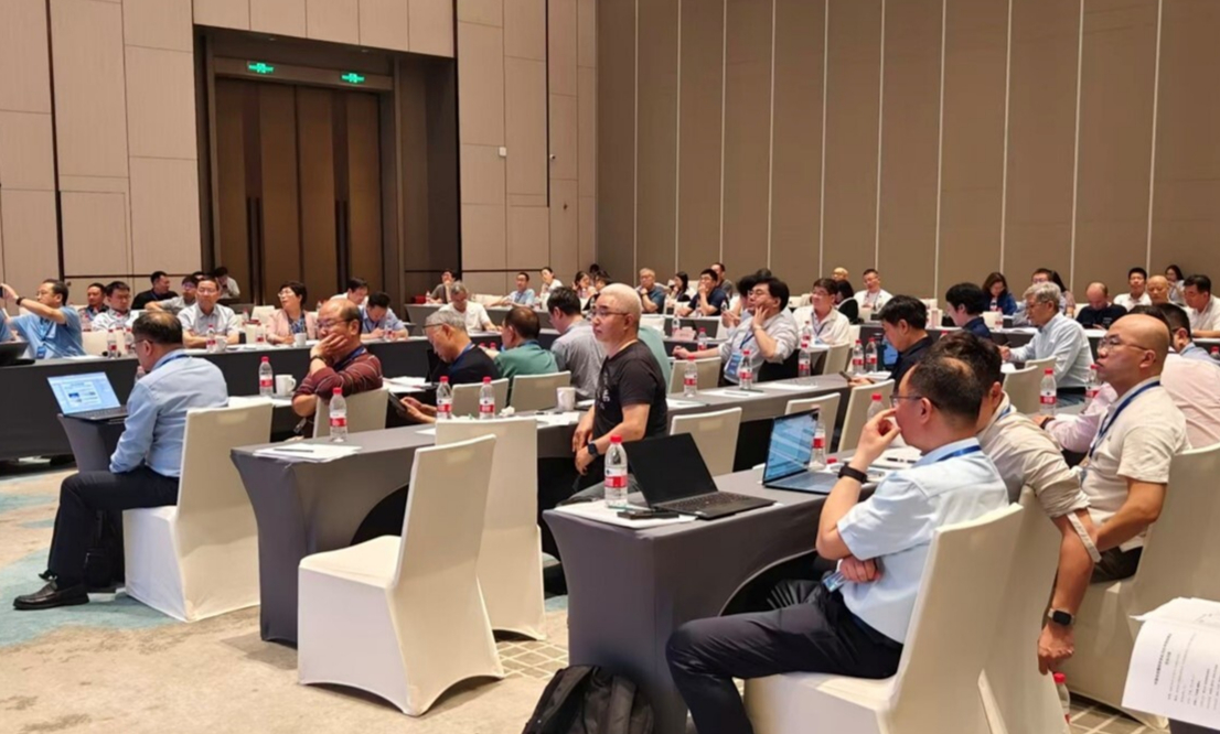
3月28至30日,中国冰冻圈科学学会2025年度学术年会暨理事会顺利举办。会议由中国冰冻圈科学学会(筹)(CSCS)等主办,中国科学院西北生态环境资源研究院冰冻圈科学与冻土工程全国重点实验室等承办。 3月28日下午,召开CSCS理事会。CSCS名誉理事长秦大河院士,理事长丁永建,副理事长效存德、杜德斌、罗勇、徐柏青、臧淑英,秘书长吴晓东等100余人出席会议。会议由丁永建和效存德分阶段主持。 秦大河在致辞中指出,理事会是对全国冰冻圈科学研究进展的年度系统梳理,也是对学科发展的集体研判。目前学会下属专业委员会覆盖了冰冻圈科学的前沿领域,学科发展已经相当成熟,我们肩负的责任也更加重大。各位理事应增强使命感和责任感,通过理事会平台积极谋划冰冻圈科学的未来发展。会上,吴晓东汇报了2025年度学会的工作进展和主要业绩。18个专业/工作委员会依次详细汇报了年度工作进展。最后,理事会讨论了专委会或工作组增设的必要性等相关事宜,同时为学会的发展建言献策。 3月29日上午,召开CSCS 2025年度学术年会。中国科学院院士秦大河、姚檀栋、王艳芬,中国工程院院士、西北研究院院长冯起,甘肃省第十三届人大常委会副主任陈克恭等280余位专家学者出席会议。丁永建主持大会开幕式。 秦大河在致辞中指出,我国冰冻圈领域相关单位联合国际多家机构申报的“面向气候行动与可持续发展的冰冻圈数字孪生计划”,正式获得联合国教科文组织批准,纳入“科学促进可持续发展国际十年(IDSSD)”倡议框架,这是我国科学家积极践行全球气候治理、推动科学服务人类发展的实际行动。下一步应高度重视人工智能等新兴技术的发展应用,助力冰冻圈科学高质量发展,为应对气候变化、推动人类可持续发展做出贡献。丁永建强调了融合人工智能促进冰冻圈科学研究的紧迫性与重大机遇。 大会颁发了2025年度施雅风冰冻圈与环境优秀科学家奖和青年科学家奖,西北研究院何兴研究员和朱国才研究员荣获优秀科学家奖。秦大河、姚檀栋为获奖人颁发证书。西北研究院高泽永研究员、李晓英研究员,西北大学吴雪娇教授、西安交通大学姚莹莹教授、中山大学郑雷教授荣获青年科学家奖。姚檀栋、冯起、王艳芬、丁永建、施建成为获奖人颁发证书。 会议特邀冯起院士作了“高寒矿区冻土-水文耦合作用与生态调控技术及集成示范”报告,王艳芬院士作了“青藏高原高寒湿地时空分布格局及其保水蓄碳功能”报告。陈克恭研究员以开普勒第一定律为例,展示了数学在地球系统科学中的应用;效存德教授阐述了地球系统安全公正边界与冰冻圈影响区安全公正转型;岭南大学李佳教授介绍了二氧化碳源汇匹配及监测;中国社会科学院俄罗斯东欧中亚研究所肖斌教授分析了冰冻圈大国博弈的新态势及战略思考;中国科学院、水利部成都山地灾害与环境研究所所长康世昌研究员论述了人工智能在冰冻圈科学研究中的应用与挑战。大会特邀报告展示了冰冻圈科学领域的最新进展和前沿方向,也凸显了冰冻圈科学和其他学科交叉融合的重要性。 大会报告结束后,丁永建主持了“冰冻圈学科发展讨论”环节,北京师范大学宋长青教授、清华大学罗勇教授、中国科学院大气物理研究所周天军研究员等多位专家阐述了冰冻圈科学未来的发展重点,其他多位与会专家围绕冰冻圈科学未来研究方向、技术创新、国际合作路径等议题展开了深入研讨。 大会分会场报告紧密围绕冰冻圈数字孪生前沿技术与应用这一大会主题,聚焦冰冻圈变化过程与模拟、冰冻圈变化与可持续发展、冰冻圈大数据挖掘与应用3个议题展开,共组织分会场报告108场,全方位展示了冰冻圈科学研究的新技术、新方法及最新学术成果。 本次会议凝聚了科学研究、技术创新与国内外合作的多方共识,研讨了未来的学科发展方向,促进了冰冻圈科学相关研究成果的交流,为冰冻圈科学研究服务应对气候变化、实现联合国可持续发展目标提供了思路。 中国冰冻圈科学学会理事会会议现场 学术年会会议合影 学术年会会议现场 秦大河院士致辞 姚檀栋院士主持特邀报告 丁永建研究员主持讨论 颁奖现场
2026-04-03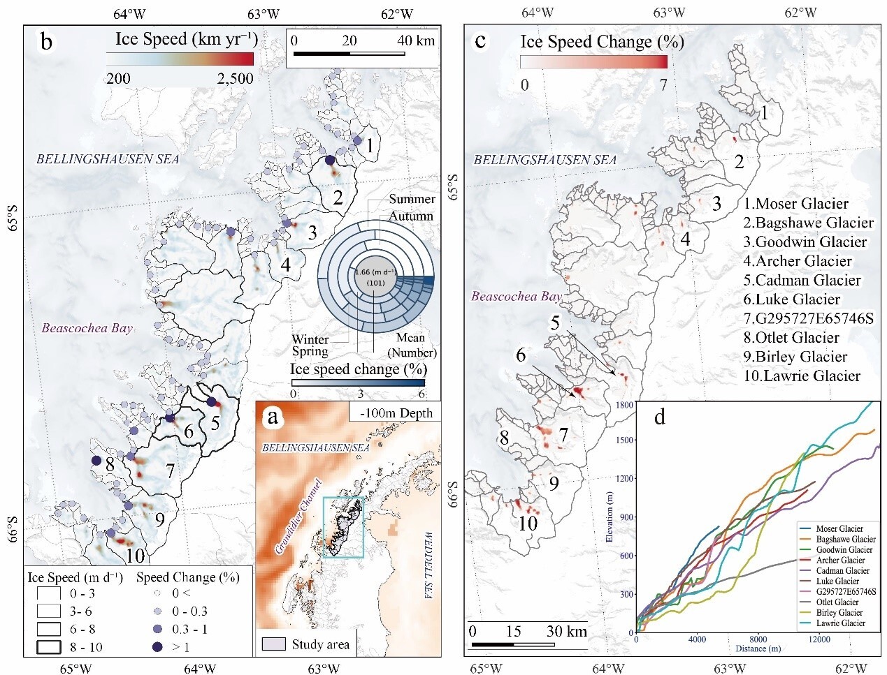
冰—气—海耦合过程是当前极地冰冻圈研究中极具挑战性的科学问题之一。全球气候变暖背景下,近几十年来南极冰盖物质损失呈加剧趋势,主要表现为入海冰川(潮汐冰川)的动力失衡与异常流动。然而,目前学界针对海洋过程对入海冰川的调控机制、冰川自身驱动机制的认识仍存在不足。因此,系统揭示南极冰川运动演化特征及其对全球气候变暖的响应机制,对深化南极冰盖的认知具有重要科学价值。 中国科学院西北生态环境资源研究院冰冻圈科学与冻土工程全国重点实验室康世昌研究员团队,基于2015年5月至2025年4月的Sentinel-1卫星观测数据,系统分析了南极半岛Beascochea海湾101条冰川流速变化特征,重点揭示了海湾上层海水变暖对冰川流速加快的关键作用。 研究表明,十年间Beascochea海湾冰川夏季平均流速增幅达1.81 ± 0.65%,较冬季均值高出约0.88%;夏季最大增速为 6.44 ± 0.74%。自2018年起,冰川流动出现大范围加速,期间最高年增速达4.04 ± 0.50% yr⁻¹。通过多种模型分析发现,该海湾0–300 m 深度的上层海洋变暖是冰川流动增速的主导因素,持续的冰川流速加快与海洋次表层浅部热量输入密切相关,而非冰川融水作用。 研究指出,在冰川动力学稳定性下降的背景下,未来海洋热力强迫可维持长期流速加快,将加剧南极半岛冰川物质损失。 该成果以Decadal glacier flow acceleration caused by upper ocean warming in the Antarctic Peninsula为题,发表于国际期刊International Journal of Applied Earth Observation and Geoinformation上。西北研究院康育龙博士为论文第一作者,康世昌研究员为论文通讯作者。该研究获中国科学院国际合作项目和甘肃省科技计划项目资助。 论文链接:https://authors.elsevier.com/sd/article/S1569-8432(26)00184-6 南极半岛Beascochea海湾冰川流速、末端高程与海温变化示意图 通过XGBoost 与 SHAP 模型分析不同驱动因子对冰川流速的影响。0-400 m 代表不同深度的海洋温度;Precip 表示冰川表面降水量;T2m 表示 2 米气温;U10m 表示 10 米风速;Tskin 表示冰川表面温度。 通过CCM模型分析不同深度海温对冰川流速的影响
2026-04-03Climate change is reshaping the risk landscape for natural gas pipelines, with landslides emerging as a major driver of technological accidents triggered by natural hazards (Natech events). Conventional Natech risk models rarely incorporate climate-sensitive parameters such as groundwater levels and soil moisture, limiting their capacity to capture evolving threats. This study develops a probabilistic model that explicitly links climate-driven landslide susceptibility to pipeline vulnerability, providing a quantitative basis for assessing pipeline failure probability under different emission projection scenarios. Using Monte Carlo simulations across five regions in China, the results show that under high-emission pathways (SSP5-8.5), pipeline failure probability in summer increases dramatically. For example, from 0.320 to 0.943 in Xinjiang, 0.112 to 0.220 in Sichuan, and 0.087 to 0.188 in Hainan. In cold regions, winter failure probability more than doubles, rising from 0.206 to 0.501 in Heilongjiang and from 0.235 to 0.488 in Beijing. These shifts reveal an overall increase in risk, intensification of seasonal contrasts, and, in some areas, a reconfiguration of high-risk periods. Sensitivity analysis highlights groundwater levels and soil moisture as the dominant drivers, with regional differences shaped by precipitation regimes, permafrost thaw, and typhoon impacts. Building on these insights, this study proposes an AI-based condition-monitoring framework that integrates real-time climate and geotechnical data to support adaptive early warning and safety management.
Study region The eastern Qilian Mountains, located on the northeastern margin of the Tibetan Plateau, span elevations from similar to 2600 to 5300 m around the Menyuan area. It is characterized by cold, alpine climatic conditions and hosts both permafrost and seasonally frozen ground, which are highly sensitive to climate change and have important hydrological and ecological implications. Study focus This study develops an enhanced multi-temporal InSAR framework to monitor frozen ground dynamics in the eastern Qilian Mountains using Sentinel-1 data from 2014 to 2024, with a particular focus on the permafrost-seasonally frozen ground transition zone around Menyuan. It addresses key challenges in permafrost monitoring by implementing a co-seismic deformation separation model, a Common Scene Stack (CSS)-based atmospheric correction method, and a time-series decomposition model with linearly varying annual amplitude to capture evolving freeze-thaw behavior under climate change. New hydrological insights for the region The results reveal clear hydrological and thermal contrasts between permafrost and seasonally frozen ground. Seasonally frozen ground exhibits higher seasonal deformation amplitudes, more rapid interannual changes, and shorter thermal response lags compared to permafrost, reflecting its more dynamic hydrothermal regime. The estimated freeze-thaw layer thickness ranges from 0 to 5.3 m, with thinning trends in seasonally frozen ground at lower elevations and slight thickening of active layers in high-elevation permafrost. These findings highlight ongoing frozen ground degradation and provide new insights into subsurface water-energy interactions and long-term cryospheric responses to climate warming in alpine environments.